Mesa to Pitt 2015

Mesa to Pitt 2015
Mesa to OBX

Saturday, May 31, 2014

Bicycling from Houston PA to Wheeling WV via Wellsburg Wv May 26

43.8 miles in 3:53....May 26.....There are so many ways to do this trip, but none of them are real easy. I'm still testing my recovery, and trying to see how the legs are bouncing back from the ride home. I decided to let GPS girl give me directions today, just to see how outrageous they might be, since she's famous for giving bizarre routes, at least in my opinion. As it turns out, I'm glad I listened to her, as I discovered a few roads in Washington County that I had never been on before. My legs also showed great improvement from the last time I rode, which makes me happy.
It was Memorial Day, so I had memories of one year ago today, when we hiked out of the Grand Canyon, after our six day rafting trip, only to find out that my mom had been moved to hospice care. Part of the reason of riding to Wheeling was to go to the cemetery, which Pam and I did. After she Jeeped down, and we had a picnic lunch and afternoon with Kenny and Lori Siburt. 
My route took me over to PA 18, north of Washington, via Pike Street and N. Main Street. Pretty normal, the way I would always go, but instead of crossing Rt. 18, I turned north, and went on Lynn Portal and Taggart roads, among a couple of others. Roads that I never had been on. They were traffic free, as was the entire ride, and I was impressed by the really nice homes and farms that were out that way. I popped out on PA 844, missing some major climbs that 844 takes right out of Washington. I was on  844 for 12 miles, riding through historic farming towns, like West Middletown and Independence. PA 844 does nothing but go up and down, most of the time a 8-9 % grades, and my legs were passing the test, along with a little help from serpentine action as I climbed. I stopped along the way and talked to a guy who was dragging a possum across the road in a trap, and he was interested in my story about riding all over. I also saw deer, turkey, rabbits, hawks, whistle pigs (groundhogs), and cardinals, my favorite bird,  ( along with magpies). PA 844 turned into WV 27 at the state line, and it was five more miles, with two, one mile sections of 9% descent down to Wellsburg at the Ohio River. One unique feature that I never saw anywhere else, between the two descents, was a sign naming a dip in the road. It was called 'Painters Run Dip, ' and it was sort of big, so I guess it deserved a name. Once into Wellsburg, it was bike trail for 18 miles, along the Ohio River, right to Wheeling Civic Center, where Pam picked me up to go to Siburts. The finish on the trail was into the wind, but it really was easy on my legs, which I probably needed.


Bicycling from Claysville, PA to Wheeling Wv by way of Majorsville, WV May 22-25

May22-25.....53.76 in 5:06....Amidst working around the house and the storage building  in Claysville, I decided to throw in a bike ride to see how the legs were recovering after some time off. I started in Claysville, and instead of taking US 40, I headed out PA 231, headed towards West Findley, which is as country as it gets. I knew what I was getting into, because I've done it before, but never with a Garmin to give me elevation changes and other cool info. Immediately, out of Claysville, I hit the major climb of the day, over 300 ft in about a mile, so I never had a chance to warm up and see how my legs felt. They screamed often and loud, but the quads felt pretty strong. PA 231 rolls significantly and often as it rides out through hills of trees and more trees, with some homes.
After about 14 miles, my legs felt good, but I could tell that western PA's hills were tenderizing me pretty quick. I came to Four Season Campground, where we had a permanent sight in the early 90's. I rode around in there, and checked out our old site, and saw how much they improved the place since we were there. After a short tour, it was riding some more ridges, until the big drop into Enlow Fork. The roads are narrow, really twisting, with no guardrails, and the drop off the ridge is so steep that I seldom let off the brakes for long, and I dropped about 500 ft in a little over a mile. It might be the steepest, craziest drop I've done in the entire country. 
Enlow Fork meets with Dunkard Fork to form Big Wheeling Creek, which I would follow, more or less for the rest of the trip. As soon as I got to creek level, the Marcellis Shale gas boom in this area became a constant companion almost all the way to Wheeling. I crossed from Pennsylvania to West Virginia on a low water bridge that is unmarked as far as the state border, and you wouldn't know the border unless someone had pointed it out to you. The former town of Majorsville is no longer, but is the Majorsville Natural Gas Processing Plant. The entire town, whose population was only about 25, was now gas works. I am convinced that Wheeling Creek will never flood again because amongst all the dry dams that have been there for a while, the gas company has a huge investment in the development there. They built several bridges that blocked the creek, where we used to put in canoes, and it was no longer passable, unless you wanted to ride through metal tubes, under the bridges. The development continued for miles, and the roads were actually improved, from the olden, quieter days. 
Suddenly, the road cut up over the hill towards Wind Ridge, and the improved road conditions went with it. I continued along the creek, though Viola, where The Tradewinds Lounge used to be. It was the site of canoe races and mud bogs back in the day, but now it was boarded up and grown over.
Soon, I came to Viola Hill, which climbed away from the creek, up a hill that was so steep, that I unclipped before starting up, in case I had to stop, or slid in the gravel. I can only remember one time in the entire country where I unclipped because of steepness ( going up to Balboa Park in San Diego) and that was as 150 yard hill, not a one mile hill like this one. Like I said, I knew what I was getting into, but I didn't know that the day would turn into 4000 ft of climbing in 50 miles. Now I know why I was so prepared for anything the western mountains could throw at me. Because, I rode these hills since I was a kid, and really didn't think too much of it, but now I know, these hills are some of the hardest climbs in our country.  
The hill ended in the town of Sand Hill, at a church and a cemetery that I was familiar with, and happy to see. Sand Hill is another of the old places with a population of about 25. I rode a ridge for a little while, before bombing back down to creek level. From there, I rolled along near the creek, but never too close, because of all the flooding that occurred before the dry dams were built. I think the last bad flood was 2004, but the old roads were built up on the ever crumbling hillsides, away from the water. At mile 37 of the trip, I was in Elm Grove, which would have been a 15 mile ride had I taken US 40. It was late, and my plans to grab a Coleman's  fish sandwich, or maybe a slice of DiCarlos pizza were shot. I headed back east on US 40, racing the fading daylight to get back to Claysville. I thought that I would have a tailwind, after getting periodically smacked by the wind all the way to Wheeling, but no. I got no assistance as I did the steady, imperceptible, climb back to Claysville. I know for a fact that I have ridden this stretch of road more often than I've ever ridden any other. When I turned 30, I started riding the trip to or/and from Wheeling every year. I continued that tradition, at least once a year, every year, until last year, when I was occupied on some other roads.
In the final analysis, my legs didn't finish as well as I had hoped, and my speed wasn't what I hoped, but they started out ok, so I just have to continue active recovery, until my old wheels want to turn again. 
After that ride, I spent a few days doing yard work and cleaning out our basement, and getting ready to go to Trader Jacks for a huge Memorial Day flea market, where we sold more stuff.

Our little corner at Trader Jacks!

Pam selling her books

The Garage Sale, and the final seven miles. May 15-21

May 15-21.....29 miles in 2:30....The week was spent in Claysville, at the National Pike Festival Days on US 40, preparing for a two day sale of items from my parents and grandparents estate, which was very successful, and the cleanup. I did manage to squeeze in a ride that included that final seven miles from the bike trail on Rt. 980, to the front door. It also included PA 50 to Washington, and some back roads back home, to make a loop, which I've done before. The ride was not as easy as I had hoped, as my legs didn't feel as good as I wanted them to. Worse, however, was that during the ride, I knew what was around the next bend, which really takes some of the fun out of the ride. I am spoiled that way, and not ready to give it up. I felt most alive when I was riding on roads that I had never been on before, and might never be on again. Today's ride included a close call with a triaxle pulling a trailer, and a kid yelling out his window at me. I caught him at the Hickory, PA firehouse, and had a few choice words for him. He respectfully listened to the speech that I had been rehearsing for 15,000 miles to give to someone who deserved it. He was really a respectful kid, even though he did yell at me  'that I belonged on a bike trail,' so I toned it down a little, and hopefully he learned something. I am not real happy about riding around here, but I will do it to stay in shape until I can ride off to somewhere else.

We are in town for a week and already Mike's picture is in the paper!!  The paper was showing some of the more unusual items found at the flea market!!!  Not sure if the unusual item was Mike or the bull and matador!!!

Bicycling from Franklin, PA to Houston, PA May 14

May14......111.3 miles in 10:38.....Things are going to slow down here for a while, and I haven't blogged in a week, but we've been busy around home, getting vehicles inspected, visiting Buddy, and generally chilling out. We camped at The Meadows, a casino two miles from our house, as we decided that we needed to stay with the RV some, and try not to cramp Buddy's style too much. First day in town we saw Buddy's track meet, which was held in Canonsburg. His girls team made the WPIAL Team Playoffs, and it was the first time I have ever seen him as a coach. I also took a drive to Morgantown WV, to see Chip Wamsley at his bike shop, where I bought the gear that got me through the whole trip. We chatted and he fixed by broken derailleur hanger, as well as several worn cables on the spot. So the store where it all began with Pam buying me Mycicle Bycicle, put me back together, so I can close the loop, by riding to North Carolina, where it all began. I will do that when I leave from home sometime in June.  We then spent three days in Franklin, at Two Mile Run State Park, about six miles from the grand kids and my daughter, Andi. The park is just now getting ready to open because it's still cold up there, and the trees had very few leaves coming out. We were parked under cover of a forest, which would normally mean we don't get satellite  TV, but we got it because there were no leaves to block the feed. In the middle of May. Wow. On Monday, I had decided that I needed a ride, and it was a long way home, so this distance qualifies as the third longest ride I've ever done. My longest ride in my life was 136 miles, on a trip to North Carolina a year before this adventure. A 112 mile ride into the Keys in Florida, with a nasty headwind was my second longest. On this trip, Pam picked me up at the end of the Montour Trail, seven miles from home, because it was pitch dark, or I would have had a more impressive mileage total.
I started out, taking some back roads from the park, into Franklin, where I began a major climb out of the Allegheny River Valley, on PA 8. It took me an hour of riding, and I was only a few miles out of Franklin, so even though I knew about the monster climb, I knew I would probably finish on the Montour Trail in the dark, very early in the ride. I decided not to pound my legs early, because of the length of the ride, and I didn't want to BONK. The weather was being cooperative, with a cloud cover and a threat of rain kept things cool. One problem I did have was a headwind, all the way to Slippery Rock, or almost 40 miles. That also slowed progress, but I just worked with it. It wasn't brutal, but always noticeable. PA 8 out of Franklin was steep and not very busy, fortunately, on a Monday morning. The road turned into a divided four lane with a nice, wide, shoulder, as it worked towards Barkleyville, on Interstate 80. For the first time on my entire trip, I was pulled over on the divided highway, by a State Trooper, and told that in Pennsylvania, unlike any other state in the whole damn Union, bicycles weren't allowed on divided state highways. He was cool about it, but it just confirms my opinion that PA is just so different than the rest of the country. State liquor stores and beer distributors. In 2014. I rest my case. The trooper told me to ride a few miles to the next exit, and get off the next exit, onto 'old' PA 8. I did, and rode on a shoulderless road with blind turns and blind hill crests, instead of a safe, wide, divided highway with a huge shoulder and immense sight distances. Don't get me started. Fortunately, there was no traffic, and i was back out onto the four lane in a few miles, just in time to negotiate the I-80 interchange. The old road also put a little more pounding on my legs, and contributed to the 5700 feet of elevation that I climbed for the trip, which is one of my bigger totals for the trip.
PA 8 continued as a two lane road with very little shoulder, from I-80 to my turn off towards Slippery Rock. Traffic picked up as I headed through a few small towns, until turning on PA 108 into The Rock. Even though I was racing daylight, it was important to me to stop at the field house on campus, where Buddy and Andi gave me some great memories, and take pictures of their profiles that hang on the Slippery Rock Wall of Fame. I also ran into Bill Jordan and Megan
Cook, who were coaches when Buddy was there. It was good to see them and the Wall, but I had a date with the Slippery Rock Dairy Queen to get some fuel for the rest of the trip. The first 40 miles had taken too long, so my hope of finishing at my front porch was pretty much gone. I followed PA 108 out of town and west, towards US 19. This stretch of road is particularly twisty and climby, but at least the headwind turned down a little when I turned south on 19. US 19 is once again hilly, like every road around here, and I noticed that the hills were greening up pretty fast as I moved only a few miles south from Franklin. There were also some mean looking, dark clouds off to my west. After about twenty miles on 19, I arrived at the town of Zelienople at the same time the rain did. I actually stopped under a roof, checked radar, and sat for a few minutes before I decided to don the rain gear and head out to finish the trip in the rain. I also turned on my GPS girl, and got off of Route 19 with the pouring rain. The roads were hilly, unknown to me, and less traffic filled. As I neared Greater Pittsburgh, I was winding a twisting on back roads that I can't even name, and only crossed a few busier, more dangerous roads, as the skies were really beginning to open up. 
I finally descended into the Ohio River Valley, far down river from where I expected to come out. I had to ride on Ohio River Blvd, Rt. 51, as traffic was beginning to hit the evening rush. Fortunately the rain stopped, and I rode through the suburbs of Economy, Baden, and Ambridge, places I have never been, at least in my memory. I eventually got off of the main drag and rode some side streets, until I get to Sewickly, where I knew I would cross the Ohio on the Sewickly Bridge. The old steel mill towns of Ambridge and Economy quickly turned to the beautiful and fashionable Sewickly, and then, it was across the bridge, and into Coraopolis. As I rode through town, it was busy, but the rush was slowing down and the Main Street filtered right into the Montour Trail. The trail was busy as many people were getting their evening exercise. I thought that since I was on the trail, that things would be leveling out, which they did, but.....as I climbed out of the Ohio River Valley, I climbed 450 ft over the first 12 miles of the trail. So, it wasn't all cruising it in, but more like a final insult to my legs. The trail was muddy and soft after the day of rain, so my speed didn't increase all that much. Pam met me at PA 980, and it was pretty dark. The road to my house is way too dangerous to ride at night, but my legs could have done it, and it would have been great to do 120 miles. But, I still have that little ride from Wheeling, where the bike broke, to Houston, to look forward to. The road goes on forever, and the party never ends.

Coach Rose talking to one of his pole vaulters

Getting serious now!

And she's over!!!


The kids and one grand kid!!  Mom Andi, birthday boy Chase, Uncle Buddy, and Aunt Jamie 

Andi and Ben giving Chase his birthday cupcake!

Big brother Carter helping Chase check out his new birthday presents!

Andi's picture from the SRU Wall of Fame

Buddy's picture from SRU Wall of Fame

Bicycling from Parkersburg, WV to Wheeling, WV May 7

May 7..... 100 miles in 8:15....total trip miles to the end of this day.....15,593.02....The theme of today's ride was bridges, power plants, small towns, and WV 2. I got an early start, for me, because the sun was as warm as I've felt in quite a while, when I walked outside at 9 am. The temperature ended up going into the eighties, and the breeze may have been a tailwind, but sometimes it was just enough to keep me cool as the day heated up. We were staying at the Walmart on the south side of Parkersburg, so the first stretch of the ride was on WV 14, through town, until I turned north on WV 68, which is old WV 2. I'm not sure if I even saw the downtown area, I didn't see the river, but I did see Parkersburg South, a high school, which is not the main city school, and  I saw a pretty big medical center and complex, before I  crossed the Little Kanawha  River and got out of town. The roads in Parkersburg are not bicycle friendly, but the sidewalks did a pretty good job getting me through some pretty heavy traffic in town. I think after being out west, my definition of 'bicycle friendly' has changed, and I'm not going to see 'bicycle friendly' east of Arizona. It's been survival of the fittest since I entered New Mexico, and I've made it to the last day of this part of the trip; all I have to do is survive today. I will finish connecting the line of travel to North Carolina later this summer.
As I left Parkersburg, I had a pretty good climb out of the Ohio River Valley, and got up over 850 ft above sea level, which was my peak for the day, and I'm glad I got it over with early, as I am still not using the climbing gears, because I don't want to change front sprockets by hand. WV 68 was terrible, as is par for the course, but after a few rollers, I went over Interstate 77, and WV 68 became WV 2 again, and I rolled downhill to river level and some intermittent shoulders. Traffic wasn't terrible, but I pulled into a driveway every once in a while to let clusters of trucks passing in both directions at once, pass. Soon I came across the Willow Island nuclear power plant, and I knew I remembered it for some reason. As I went by, I saw the plaque, that commemorated the lives lost when a cooling tower collapsed when it was under construction. It happened within a few years of the Silver Bridge collapse a few miles south. Being from West Virginia, I remember those tragedies well. 
Next was the town of St. Mary's, which I remember because one of the greatest distance runners of my generation, Steve Taylor, ran high school track and cross country there, breaking all sorts of distance records. It's also a town where the train tracks run right through the middle of Main Street. Crazy. Too bad a train didn't come when I was there. Just north of St. Mary's , I came upon a line painting project by WVDot, and they had traffic stopped. I rode down the shoulder, and didn't ask permission, but went right past the road block. I rode for at least five miles with zero traffic, on an improved area where there was a shoulder. Most of the road had such terrible shoulders that there were no lines to paint. They would have been painting broken asphalt and potholes. As soon as I got into the town of Friendly, WV, the shoulder went to hell, and all the traffic came through in a parade. I just pulled off the road, posed Mycicle Bycicle (AKA Bike) with a Mail Pouch barn and waited for it all to pass.
Then it was on to the neat little town of Sistersville, where the last operating ferry on the Ohio River still takes cars over to Ohio. It's a small ferry, and has been saved several times by historical types, for history as much as function. The homes were all old Victorian mansions on the side streets.
Five more miles north on bad road and I came to Paden City, where most of the world's marbles are produced at Marble King. I had to follow a gravel road down by the river, to find the place, which was marked by one small sign, and the place wasn't very impressive, but hey, I loved marbles when I was a kid, and if you own any, they were probably produced in that old, rusty plant.
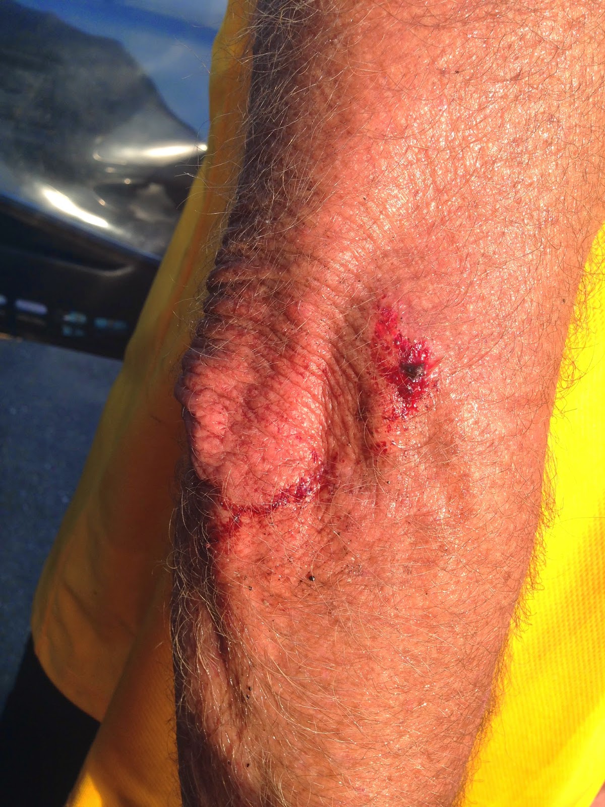
I got into the biggest town between Parkersburg and Wheeling just about the time school let out in New Martinsville. I had been there many times, but never went off the main road to check out the downtown area, until today. As I stopped to take the picture of the Sheriffs Office, my front wheel slid out in some gravel, and I laid it down, and rolled out of it in the middle of the street. Nice. A little elbow blood, and a little squeak, but no worse off for the experience. 
North of New Martinsville, I crossed the Mason-Dixon Line, and got into the chemical plant area of the trip, right when shift workers were getting out for the day. It wasn't as crazy as I thought it could have been, but it was a race to get to the Kammer Power Plant, where I knew the four lane would begin. I was hoping they had improved this area south of Kammer, in the thirty years since I had been there, but no. Actually, they were beginning a widening project, but the construction just made the race to the four lane a little crazier.
 I finally made the four lane, and could relax a little, but the shoulders were filled with rocks and gravel, even though there was no glass or tire shrapnel, fortunately and surprisingly. It was quitting time, and I'll put the redneck gear heads of Moundsville, WV up against any in the country, so I was glad to get to the Moundsville/Glendale multi purpose trail, which ran right along the river for a few miles, and I had never seen it. I popped out right at the base of 'The Narrows,'which is a narrow road between Moundsville and McMechan-Benwood-Wheeling. It is notorious for falling rocks, with a cliff on the right side and a drop off to the river on the other. It's still four lane, but the shoulder is covered with fallen rock shrapnel that the big chain fence didn't catch. By that time, it was going on six o'clock, but traffic wasn't terrible. I don't think there is anyone left in Wheeling, actually, as the population has basically been cut in half since I lived here. After the Narrows, I got off of WV 2 again, and traveled a very narrow hillside, but main roads, through McMechan and Benwood, into South Wheeling. In South Wheeling I once again jumped on a bike path, the Heritage Trail, and took it all the way through Wheeling to Elm Grove, where I was meeting Pam a DiCarlos, home of the worlds best pizza ( in my opinion) ( sorry Briggs. ). As I pulled off the bike trail, I had one more little hill before coasting into the finish, and as I stepped on the pedal, the hanger for my derailleur broke, and twisted up in the spokes of my back wheel. Of course I went down, for the second time today. It is the most major breakdown of the entire trip, one that I can not repair, that might turn out to be a major break, depending on what bent, and it happened less than a half mile from the finish of a 15,000+ mile bike trip. This has been the story of this entire trip. God has been with us, and I have been as lucky as I possibly could have imagined. Everything from only having a few flat tires ( I heard of guys having as many in one day as I had on the entire trip), to having someone like my wife to work out all the details to perfection,  for over a year and a half. I didn't get bitten by any animals, or get in any fights with the country's drivers, who were really great 99.99 % of the time, and I didn't end up on the grill of any eighteen wheelers, like I had feared. This all isn't over. We are just going to take a short break to take care of some housekeeping and family. The road goes on forever, and this party is not going to end.

The Little Kanawha River Bridge as Mike left Parkersburg

Of all the animals (and roadkill) Mike has taken pictures of, this is the first bat!!!

Mike saw this sign at the last second, but his Uncle John was married in Cow Creek, WV and he was an usher.

Willow Island Power Plant

A close-up

The monument to the cooling tower collapse

The entire area

The St Mary's Bridge across the Ohio River

George Washington and Mycicle were here, but not at the same time!

Trains run right down Main Street in St Mary's!


Middle Island Wildlife and Recreation Area

No gates, just flashing lights for the Main Street train!

The gravel track that produced Steve Taylor, one of WV's greatest distance runners

Mycicle resting while a line of traffic went by in Sistersville

Sistersville is very old and historical

The Little Sistersville Ferry across the narrow stretch of the Ohio River, below the locks and dam

Welcome sign for those who cross on the ferry

Cool architecture on the side streets

Marble King factory in Paden City, WV

If you've lost your marbles, new ones are made here!!

Another stretch of narrow WV2 with trucks aplenty

They are proud of their high school sports

More champions!

New Martinsville, WV (at rush hour for Mike)

Downtown New Martinsville (not on WV2)

Sheriff's office where Mike was stopping for this picture when he laid Mycicle down for the first time

"Country Road" Ford - yep, we're in West Virginia!

New Martinsville Locks and Dam, the river gets much wider north of the dam

The Mason-Dixon Line

The actual, original marker, covered so acid rain from the industries don't destroy it!

A familiar sight in WV

Kammer Plant - the biggest of them all

Here Mike finally found 4 lanes and shoulders

These stacks are tall!

The smaller stacks are at the older plant

WV coal

The Moundsville Country Club, where Mike's dad was inducted into the John Marshall High School Hall of Fame

The Moundsville Bridge that Mike's brother helped to design - and it's still standing!!!

Home of the reddest necks and geariest heads in the USA!

Moundsville-Glendale bike trail

Coal mine history

The Bellaire Toll Bridge - it's been condemned for at least 20 years!

This is how they talk to you in Moundsville!

Mike's back home, where the "millhunks or hunkies" prospered 50 years ago

Mike and his friends used to climb on barges like this back in the day

The home of Mail Pouch Tobacco and Swisher Sweets

The field where Mike's daughter decided she could be a runner instead of a juvenile delinquent

The Wheeling Heritage Trail at Tunnel Green

It was cool, wet and dark in there

The unglamorous finish of today's ride!  (and the trip!)


Poor Mycicle Bycicle!


Chip Wamsley in Morgantown, WV repairing Mycicle Bycicle the next day!  If you are ever traveling through Morgantown and need your bike repaired, go to Chip at Wamsley's Bike Shop!  He's the best!