Mesa to Pitt 2015

Mesa to Pitt 2015
Mesa to OBX

Saturday, April 5, 2014

Bicycling from Alamogordo, NM to Ruidoso Downs, NM March 31

45.95 miles in 3:50.....just in case you're interested...... I rode my 13,733.82 mile today since we left on this adventure in October of 2012. Today, amidst wind and fire warnings that are up for the whole week in New Mexico, I set off with mild breezes that picked up as the day went on. By the end of the day, Weatherbug said I had been smacked by 35 mph gusts, but it was at my back ALL day. My back actually got cold from the wind as I got to the higher elevations!
The trip started with a 8 mile ride headed north to the old and very west looking town of Tularosa, where US70 turned east, towards the Sacramento Mountains. The climb started very gradually, and then, even though it got steeper, it was a very gradual 3-5% grade...... for 23 miles! Mt. Lemmon was the longest non stop climb in Arizona, and I went uphill for 20 miles there, but I climbed over 5000 ft. Today's ride may well be the longest nonstop climb in New Mexico, (even though I doubt it), but I only climbed 3250 ft. And with a tailwind, it just wasn't that bad, and I didn't push as hard as I could have either. I just enjoyed the ride. As I climbed, I could look back into the valley, and see the very white area of sand that we visited yesterday. It was a unique view. Eventually I entered the Mescalero Apache Reservation. There was some interesting art work on the concrete walls along US70, and the Rez seemed to be pretty clean and modern compared to some that I have ridden through. I was only chased by two dogs, which is a concern on every Rez that I have been through. One dog made it across four lanes, but didn't have much interest in running uphill, and the second, younger dog was bringing it, when he slammed on the brakes because a red car going downhill was going to plant it. Smart dog, but he's going to have burn marks on his foot pads from stopping so quickly. Even if he would have gotten close, I keep my bear spray in a holster on my handlebars now, and I would have hosed him down. I have not had to defend myself against a dog on this entire trip. But there were some I wasn't sure about, until they pulled up at the last second. I've been very lucky, but I didn't start carrying bear spray full time, until after I left San Diego. 
I was on Apache property until I went over the summit, and as the descent began, I came to the first of three casinos that fuel the Indian economy. They also have a ski resort, called Ski Apache, which supposedly still has snow. I did see some snow on the 12000 ft Sierra Blanca as I went over the summit, and that was enough for me. The descent lasted for twelve miles of the same grade I went up, and it continued right through the towns of Ruidoso and Ruidoso Downs. I was cruising through town at 35 mph at one point. Three or four miles east of Ruidoso Downs, I came to the Circle B campground where Pam had set up. This area is a huge tourist area, with the skiing in the winter, and the cooler mountain temperatures in the summer. It also seems to be a cultural center, with lots of art and museums, and it is not that far from Albuquerque, which is a big town. If you have heard of Ruidoso Downs, like I have, you know it is a quarter horse race track which hosts the 2.5 million dollar All American Futurity Horse Race on Labor Day, the richest quarter horse race in the USA. I went right past the track, but didn't even take a picture, because it didn't amount to very much. There weren't a whole lot of grandstands, and the little casino that was there was very small. It wasn't near as big as Wheeling Downs and Casino. Billy the Kid is also a big draw around here, as this was his main stomping grounds, and he is buried nearby. Billy killed 21 men, and died when he was 21 yrs old. They had a three year incident called the Lincoln War, which I hadn't heard of. It was between two factions battling for economic control. A whole bunch of people died, but Billy was the only one to be convicted of anything, but he escaped from jail, and they never did hang him. A sheriff named Pat Garrett shot him when he was allegedly unarmed at the home of his girlfriend, even though there are some different versions of the story. Pam and I went to the Billy the Kid Visitor Center in town, and read the whole story, which was hanging on the wall of the center.


Is this a storm chaser or ghost busters car???

Giant pistachio on one of the areas pistachio farms.

Climbing to Apache pass - the white stripe is the gypsum dunes

There is a huge cross up at the top, but it's not Mount Sinai!

US 70 - gradual climb for 20+ miles

Still climbing - note the elk sign


Artwork on the Apache Reservation


The black and orange symbol was on everything

The pines started at above 5000 feet - it's been a long time since we've seen them!


Would you trust her to do yours???  Ha Ha!

Nearing the summit....

Made it!!

Looking over at snow on Sierra Bianca - 12,000 ft

As close as we want to get to snow


We passed the Billy the Kid casino

At the visitors center they had all of the following, beautiful horse sculptures


The visitors center had all sorts of information about Billy the Kid


Smokey the Bear and Bambi!  Actually Smokey was a real bear cub found near Ruidoso Downs area.

Wednesday, April 2, 2014

A Day at the White Sands National Monument March 30

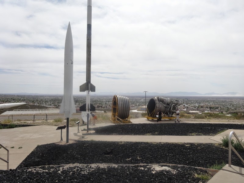
Sunday, March 30, 2014....A rest day was in order, after six straight days of riding, totaling about 418 miles, had me dragging a bit. Also, Pam and I both had an interest in taking a closer look at the White Sands National Monument, so that's what we did, as well as checking out the New Mexico Space Museum. I never realized that New Mexico had such a role in early NASA, land speed records, and missile development, including the atom bomb, in the 1950's and 60's.
We went to the White Sands Monument first, because the afternoon was supposed to bring big winds, which would be blowing sand. The park was 275 square miles of the whitest Gypsum sand, I've ever seen or imagined. Gypsum is in all the mountains that surround this basin. All the water that runs into this huge area( drainage basin is the size of Connecticut), runs to a lake that totally evaporates and leaves the gypsum crystals on the dry lake bed. The prevailing southeast winds blow the crystals until they are fine granules. The granules and the wind combine to create the dunes, and the monument. Gypsum sand is very light and sparkly as compared to sand that we know, and to me, it looked exactly like snow. The eight mile road looped through a very small portion of the dunes, and it even looked like scraped, icy roads as we drove on them. People were everywhere with saucer sleds, riding down the dunes. I even tried it, thanks to a nice family who let me use their saucer. It didn't go to well, but little kids like it. Families were cooking out and picnicking in shelters at the pullouts, and the wind wasn't blowing yet, fortunately. After we left and went to the space museum, we could feel the high winds, and as we looked out over the valley we could see the white clouds of gypsum sand blowing high into the air. 
We finished our day by going to the IMAX theater at the space museum, and watching the presentation called 'Tornado Alley." So now we are ready to head into Texas, Oklahoma, Arkansas, and Missouri in April. Yep- that's tornado alley, but hopefully we'll be through there before peak tornado season, which is May, but the weather is so weird lately, you know.....

Doesn't this look like snow???

Hiking out the boardwalk to  view the valley.  There was a "field trip" group from New Mexico Military Institute walking out there too!


The road looks like scraped snow and ice and it's crispy too!


The Military Institute cadets had some fun too!

         Mike sled riding at White Sands!!  Hope he was better at this in his younger years!!!


Road closes when the missiles are being tested.

At the space museum

The museum was up on a hill looking down over the town

Hedgehog cactus in bloom

Missile that was tested here


Looking out over the white sands dunes - trying to show how the sand is kicking up....


Biking from Las Cruces, NM to Alamogordo, NM March 29

68.18 miles in 5:04....I left the Walmart parking lot, and the first 12 miles included an elevation gain of about 1500 ft, through Augustin Pass, over the Organ Mountains. Today's entire route was on US70, which is a great road with huge, clean shoulders, even though the first 5-6 miles were on the Bataan Memorial Highway, a road that parallels US 70, and is a business access road. The climb over the pass was made easier by the brand new asphalt they had just put down, but it was made more difficult by the wind out of the southeast, which just didn't help the speed of the climb, as I was headed pretty much east northeast. I saw two or three other bikers, so the summit is a popular training ride in LasCruces ( which I was surprised to learn has over 100, 000 people). As I summited the pass, the Tularosa Basin opened up before my eyes, home of the White Sands Missile Range, and I believe, the Trinity Site, where the first A bomb was set off before we used the weapon on Japan. The Trinity Site is only open to the public two days of the year, but the missile range is pretty active, because they close US 70 down a couple times a month for testing.
The trip across the floor of the basin was very flat and windless, AFTER I dropped 1700 ft in nine miles at a pretty high rate of speed. Two things happened while I was putting in the 40 miles across the basin. One, at some point I came to a dune of pure, white sand, out in the middle of the salt cedar trees and other scrub ground cover. This was just a preview to the White Sands National Monument, which we are going to see tomorrow. There was one dune that ran along the road for about a half mile, that could have been on the Outer Banks, in the middle of a total different looking desert landscape. The other interesting thing that happened, was Carl Dobinski, from Coatesville, Pennsylvania. As I was riding along, thirty miles from the nearest town, I came upon a guy who was walking across the country, pushing a stroller type cart. We talked for about a half an hour. It turns out that he started walking in Philadelphia and made it to Abilene, Texas, before snow and below freezing headwinds caused him to get a ride to San Diego to get to warmer weather. Right now, he is walking from San Diego to Abilene to complete his cross country journey, before going home. 
Right after talking to Carl, I stopped at the White Sands National Monument Visitors Center to get a feel for what we might see, then it was off to Alamogordo, which I could see from about 13 miles away, because it was uphill from where I was to the town, at the base of the Sacramento Mountains. The town has about 30,000 people, and it was long and narrow, but not because it's in a river valley like a lot of towns I've been seeing, but because it's up against a mountain range. There are no rivers in the Tularosa Basin. It's called a basin because its like a 'cereal bowl, surrounded by mountains, and the water has no place to go. It sinks in the ground, and bubbles up every once in a while, and that has something to do with the gypsum sand dunes in the National Monument.


Cowboy history

Tumbleweed stuck in power lines

The climb out of Las Cruces ended here!

Entering the Tularosa Basin

Also entering the White Sands Missile Range

Beautiful mountain scenery

Debris has fallen on US 70 during missile tests, so they shut down the highway during tests

Carl in the middle of nowhere!

Carl and his cart

First sighting of gypsum sand (AKA white sands).  They use gypsum to make plaster board and drywall.


Dried up lake beds in the basin


Would you buy a car off of this guy???!

Bicycling Deming NM to Las Cruces, NM March 28

71.07 miles in 4:36.....The weather forecasts are saying that today and tomorrow are going to be the picks of the litter, then it is going down hill, mostly wind involved predictions of dust and fire danger. We had toyed with the idea of spending a  day in Deming, but I decided a good travel day shouldn't be wasted on as unworthy a sight as Deming. Nothing personal, but there wasn't much going on there, and the Escapees campground we were staying at was also a disappointment ( read as ' no hot tub'). So, on the road it was, heading out of town on NM 549 with a 15-20 mph wind perfectly at my back. NM 549 pretty much runs parallel with I-10, sometimes a little closer, sometimes not so close. The surface was a little bumpy, but from what I could tell, the shoulder on I-10 wasn't any better at this point. The thing I like about 549 was that it climbed just enough so I could look down over I-10 and the railroad tracks that parallel it, to see the trucks and the trains off in the distance. There were a few roads going off of 549, but mostly farm roads and one road to Rock Hound State Park. Only a few cars shared the  32 mile stretch of road with me, as I whizzed along with my tailwind. I watched as the nothingness passed me by. Same flat, browned off grass and dead scrub brush that I've been seeing for three days now. Not even any critters to see. At one point, I did come to a motorcycle race track, that was fully involved, with about fifty motorcycles racing it out, full throttle, on a Friday morning. That was cool, but not cool enough for me to stop for very long.
After 32 miles, I finally was forced on to I-10, and even though the shoulder was nicely paved, it was pretty dirty with tire shrapnel, so I had to be on the alert. I still love my 'flack jacket' tires, because I know I'm hitting some steel belt wires, and I'm also in the middle of goat head country, and I'm having not a single problem. As I approached Las Cruces, the road comes off the high plains, and the town is 500 ft down, in the Rio Grande River Valley, and it was all laid out right in front of me for a fantastic view. I descended into the valley, and before heading to our Walmart, where Pam had set up for a free night, I headed south, down stream about 10 miles to check out New Mexico State University. It is another nice campus, and the kids were on spring break, just like when I was a Arizona and Arizona State last week. I rode through the walkways that would normally be filled with students, but the place was dead. I followed tradition and found the football stadium, which was small, maybe holding 30-35,000, with a  dormant live grass surface. I read their wall of fame, and I had never heard of anyone. They compete in the WAC, the Western Athletic Conference, which is a notch below the big boys. The facilities were also nice, but a notch below the larger programs. I found the track, and it was nothing to write home about, but I still liked the campus, with some big mountains serving as a backdrop. 
After my ride through the town, I had added on about 20 miles to my trip, but it was worth it to check out a pretty big town that seems to be still growing. 
Pam and I took advantage of being in our last town of any size for a while, and went to Best Buy to get a new TV for the front of the RV. The old one croaked a couple of days ago, so we spent the evening in the Walmart parking lot installing the new one. We had to do some remodeling of the metal bracket to get a Samsung TV to fit on a Sharp bracket, and Pam made to trips into Walmart to buy a drill bit and a hack saw, but the job got done, and we have a new TV.


Descending into Las Cruces

The Rio Grande Valley and Organ Mountains

The Rio Grande - wide and dry

NMSU is located in Las Cruces

Football press box

Of course Mike got into the stadium!  But the grass is beat up.

Panoramic of stadium

All the buildings at NMSU have this type of architecture