Mesa to Pitt 2015

Mesa to Pitt 2015
Mesa to OBX

Wednesday, April 2, 2014

Lordsburg NM to Deming, NM March 27

65.64 miles in 3:43....The last time I was in this area, almost exactly a year ago, we were heading west, but just about to turn north, to go to Northern Arizona. We were in a town, about twenty miles south of here, on the Mexican border, and we had to hunker down for a extra day because of the high winds, and our first exposure to a nasty dust storm, which I have taken to calling a 'haboob'. I was cussing the terrible winds, and pretty much struggling with them. I knew at the time I was riding into the wind, and most people who ride across the country ride west to east, to have the wind at their back. Well, this time through, I have the wind at MY back, as I am now going west to east. That was never more true than today, as I had 15-25 mph with higher gusts, pushing me for 60 miles. That, combined with the truck traffic and smooth shoulder on I-10, had me flying. Just about the entire trip was on I-10, as there are just no other roads around here. There is not much of anything. All the talk about dust raised the topic in the news about valley fever, a disease that we had never heard of. There is a fungus that is in the soil, that blows in the wind, people breath it in, and get sick. They warn everyone who has compromised health to stay indoors during wind events. One thing that caught my attention was that they said bikers and runners are exposed when breathing in dust, that sometimes you can't see in the air. Some people get better without medicine, but some people die from this valley fever. Hmmmm.Between Lordsburg and Deming, I think there were two exits for touristy rest stops, and one exit for a concrete or gravel business if some sort. Only one road was paved for more than a quarter mile. The terrain was flat and desolate, with very little growth if any sort. That is why dust storms are such a major concern around here. There were mountains way off in the distance, but it was flat, flat, flat. That being said, it was crazy when I crossed the continental divide! From Lordsburg, I climbed, ever so slightly for about 500 ft, over about twenty miles....hardly noticeable. After I passed the continental divide sign, I descended about 2-300 ft over the next twenty miles.... Hardly noticeable, but it was the continental divide, so I noticed. My speed increased a few mph on the downhill side, and I watched my elevation on my Garmin GPS, or I would have never known. Since we came through this general area before, I remember crossing the divide in Silver City, NM, a little north of here, but that crossing was up in the mountains, at the crest if a hill, like the continental divide 'should' be, not in the middle of a 'flat' desert, like it was today. 
For the first three hours of my trip, I averaged over 18 mph, which is rocking it for me, but I slowed down when I got off the interstate about ten miles out of Deming, and cruised NM 419 into town. The scenery wasn't much different, but I did see some nice homes, and I saw the biggest chili pepper plant in the US, according to a flyer I read the other day. I also saw 4 dead cows, that had been dead for quite a while, skin and heads intact, picked clean by buzzards. It reminded me that the last time I was in this area I saw the same thing. I don't know if they starved, dehydrated, or were diseased, but the farmers just leave them lay where they fall out here. There were  a few groups of live cattle as I rode along, usually by a windmill that pulls water for a well, or by a single green tree, which told me there was water there. I also saw about 8-10 trains, because the railroad tracks ran parallel with I-10. It is always cool for me to see a real long train chugging across a flat area, where I can see the whole train. Another random observation....I always notice a lot of burned asphalt where vehicles caught fire when I am riding an interstate, and I usually have to be careful going through the debris that are left there. Today I saw a truck that had incinerated on the shoulder, and they just left it there. About the only thing I could make out may  have  been some paint cans, so it must have been a truck hauling something flammable in cans, but it was just in a big pile on the other shoulder, and I don't even think there were any cones or warning devices around it. Crazy.
When I got into Deming, I did a little tour of the town, just cruising up and down some streets, and a couple of times I got turned back into the wind, and it was NASTY. It was cool today also, as I don't think temps got out if the 60's, but the wind seemed cooler. 


Burned truck and debris on I-10

Flattest continental divide ever!

I-10 with a clean shoulder

Tailwinds again today!

Life in the Wild West!!

Chili pepper capital of USA

Old Texaco station from better days
Adobe ranch of yesteryear

Southern Pacific RR is huge around here.  This is the Deming visitor center.

Rodeo New Mexico to Lordsburg, NM March 26

46.83 miles in 3:26....The wind howled all night long, and the forecast says it's going to get worse as the day went on today. Armed with that information, we decided it would be a short trip today, and we would get settled early and ride out the wind and the dust storms and whatever else came along. Our stopping points are limited now that we are in the middle of New Mexico. There is not really much here.  I had a choice between doing a 40+ miler or over a century (100 miler), to the next town of Deming. There is probably somewhere to stop in between, but you just never know, so Lordsburg it was. As I pulled out of Rusty's RV Ranch in Rodeo, I had a dead tailwind that literally blew me down the road for the first seven miles, still on NM 80. In Arizona it was AZ 80, and in a long ago time before that it was US 80. I just learned that the sections of 80 I've been on since leaving San Diego are the last remaining fragments of the Dixie Overland Highway, which was built from coast to coast in and around 1927. It was replaced, for the most part by Interstate 10. Anyhow, as I was getting assisted down NM 80, I did not have a vehicle pass me until I had ridden eleven miles. I had maybe 20 vehicles pass me on the thirty mile trip, until I hooked up with I-10. I started, like I said, with a seven mile stretch without a car or a turn in the road. At that point I went around a curve to the right, and started about a 500 ft. climb over the next five mile straightaway. It was a huge difference, with the wind blowing in my right ear hole, and an elevation gain. Once I peaked that climb, it seemed like it was all down hill, with just a roller or two all the way to the interstate. NM80 provided smooth asphalt and a decent shoulder, and at the terminus of the road at I-10, there were some gas stations and stores, but every single one was shuttered, a modern day ghost town. The scenery, just like yesterday, was fantastic on NM80. Once I got on I-10, the mountains were all off in the distance, and the grasslands were replaced by very flat terrain of seemingly hardened mud. It looked like it was the bottom of a dried up lake, even though we are at an elevation of about 4100 ft.
The next 16 miles were headed east on I-10, the ONLY road in this desolate area. The wind was picking up a little, but not as much as I expected, and it was a tail, if anything. I probably could have been blown the additional 60 miles to Deming, but the signs warning of dust and zero visibility, discouraged any thoughts I might have had about stretching it. Pam set up in a KOA, and when I pulled into Lordsburg, I spent some time riding up and down the streets looking for something interesting. The only thing I found was the high school football field and track, which was as nice as any I've seen anywhere. Other than that, the town was pretty boarded up. There was a courthouse, a Dollar General, a Family Dollar, a strip of motels, both chain and mom and pop that served the interstate, and not much else to hold my interest. It also served as a freight train yard, as there were two trains parked along Business 10, which was the main drag. As I searched for the KOA, I came upon a McDonald's, and the Jeep was in the lot. Pam had gone out investigating also, found nothing, and decided to eat lunch there. I stopped in and said 'hi', and we headed for the KOA. 
The wind did rock the rest of the day, but we didn't see any haboobs, as we had suspected in the worst case scenario.
"Ghost" mining town along the road as Mike climbed out of Rodeo

Great mountain views along the ride


We were warned about them, but didn't see them


The New Mexico flag

Downtown Lordsburg - don't blink!

What's wrong with this sign????

Biking from Douglas AZ to Rodeo, New Mexico March 25

March 25.....58.09 miles in 4:13.....All the time I was riding, I kept having the recurring thought that 'This is beautiful, and this is a great ride!' The mountains were nice to look at, but to not have to climb over, and the long ribbons of highway cut through flat plains that were almost golden, with dry grasses. The stiff wind was, fortunately, a tail wind most of the time. The road was in great shape, and after the first ten miles out of Douglas, I didn't have a shoulder, but I didn't need one. Traffic was practically non existent. There were 3-4 mile stretches where I never touched the handlebars, just sat up, let the wind catch my back, and pedaled no handed. I had to climb about 500 ft to get out of the valley that contained Douglas, but it was a very gradual climb, and I hardly noticed it. AZ 80 then wound around a pretty big mountain, but after that, the road seemed to be straight as an arrow, with a gradual descent, all the way to New Mexico. There were no towns, unless you count the two houses that had a green sign that said it was the town of Apache. Right outside of that town was a monument built to commemorate the nearby surrender of Geronimo, thereby ending the war between the Indians and the US government. The town of Rodeo, just inside the New Mexico border, only had about twenty houses, a store, a bar and a church, with two picnic tables that they called a town park. There was, however, always a ranch building or two in sight, often far off in the distance. As I began my descent on the second half of the ride, I was always accompanied by a few scattered cattle, taking advantage of the grasslands, including one stud cow with the biggest horns I've ever seen, still out in a field, not in captivity or hanging on a wall somewhere.
As I rode, I was almost always in sunshine, even though I could see ominous grey rain clouds off to my left, and out in front of me. I got a few drops of rain as I stopped to take a picture at the Geronimo monument, so I knew rain was around me. As I crossed into New Mexico, I was swallowed up by the cloud cover, and the tailwind that I had been enjoying turned to a chilly headwind. The last eight miles, through Rodeo, to Rusty's RV ranch were pretty miserable, ending a great ride on a not so great note. The wind continued throughout the evening, and it was sometimes accompanied by rain. The symbolism was not lost on me, that the weather changed just as I crossed into New Mexico. It signified that we are out of the Sonoran Desert and its dry, warm temperatures, and we are heading east for real now, into the higher elevations and volatile spring weather that we are bound to encounter until we are home.  It made me feel a little better that the Phoenix / Tucson area had a haboob that was 5000 ft tall and thirty miles wide blow through today, that we may have been caught in if we were still there. The forecast around here for the next two days is for high winds and dust storms, so I am going to try to advance a little bit each morning, before the predicted 30-40 mph winds kick up. We'll see how that goes.
As Pam and I strolled around Rusty's RV Ranch in the early evening, we were attacked by two geese, who must have had a nest by a pond we were walking by. After making a ton of noise as we approached, one goose actually charged me, and I kicked him gently in the beak two times to hold him off. As we walked away, he charged me again, and this time I spooked him with a rock that I threw his way, and he backed off before I had to punt him. They did a very aggressive job of protecting their brood, but I have to say, I've never been attacked by a goose before, and I did a good job of protecting Pam.

Free speech out on the range.....

Flat road, nice shoulder and mountains in the future

The clouds are moving in

Unusual mountain formation
Just beautiful

Spring has come to Arizona


Big stud cow!


This is where Geronimo surrendered

Geronimo monument


Welcome with dark clouds


There was a neat koi pond at our campground with many frogs - can you find him????

The attack geese

Across the road from our campground we found.......soda machines!  Go figure?!

The campground also had these birds

Our campsite at Rusty's RV Ranch

Footage from our TV regarding the Phoenix haboob

Thank goodness we missed this!!!

Biking from Tombstone to Douglas, AZ March 24

March 24.....59.35 miles in 4:47....The route was AZ 80 south, all the way to Douglas, which sits right on the border with Mexico. The ride out of Tombstone was rolling for quite a while, never really emptying off the ridge that tombstone was on, and always having a view of the valley, off to the right or left. I could see the town of Sierra Vista off to my right, eventually, down in the valley, about ten to twenty miles off in the distance. After about 15-20 miles, I too had a pretty good descent, only to begin a climb at about the 15 mile mark of my ride, that ascended for about five miles at 5-6%. I wish I could say my legs felt better than they did, but they never had that zip, going up this hill. The three bikers who caught me from behind near the top, had more juice than me, or I would have gone with them. When I finally did summit the mountain, at about 5800-5900 ft, the descent took me right into the Mule Pass Tunnel. I pulled out my camera and took a picture of the approaching tunnel as I rode no handed, and started to build speed pretty quick. That move caused me to drop my camera while going about 25 mph. It's the first time I've dropped it in 13000 miles, but it still pissed me off as it bounced and skidded down the shoulder. I slammed the breaks as I went into the tunnel, and walked back out to find the camera easily, but the memory card, about one inch square and very flat, shot out when the little door holding it in gave way. I had a lot of pictures on that card, so I decided right away that even if the camera was a loss, I HAD to find that card. I checked the lane of traffic as cars whizzed by me, to make sure it wasn't getting run over, then I could begin searching the shoulder, that was gravel, dead leaves  and weeds. I searched for about five minutes before I finally found the card, and I was greatly relieved. The camera took some body shots, and the battery door was bent and broken, but some pliers and athletic training tape fixed it right up (when I got to the RV), and it seems to be working. Whew!
The descent went on for about five miles, including the last mile, where I could see the copper mining town of Bisbee in a hollow (canyon) off to my left. The mountains I had just come through were rocky, and pretty big, making for some nice scenery. I did finally think of the fact that I could take some pictures with my phone, which I did, so not all was lost. I pulled off the exit at historical downtown, Bisbee, and spent some time riding through the narrow streets of this little tourist town, which was filled with little shops. After riding about a mile looking for a quick place to grab a bite, I settled on a Klondike Bar from a Circle K convenience store. As I was heading out of town, I came upon a support wagon from Wisconsin, that a large group of bicyclers had just departed from. I stopped and chatted, and the guy said that they were doing a big loop from Tuscon, and they took a different route from me, but were all staying in a hotel in Douglas tonight. Pam found us a place at the Cochise County Fairgrounds with water and electric for $15. (We were the only people staying there, so they gave Pam the key to the fairgrounds gate, and we locked ourselves in for the night!) 
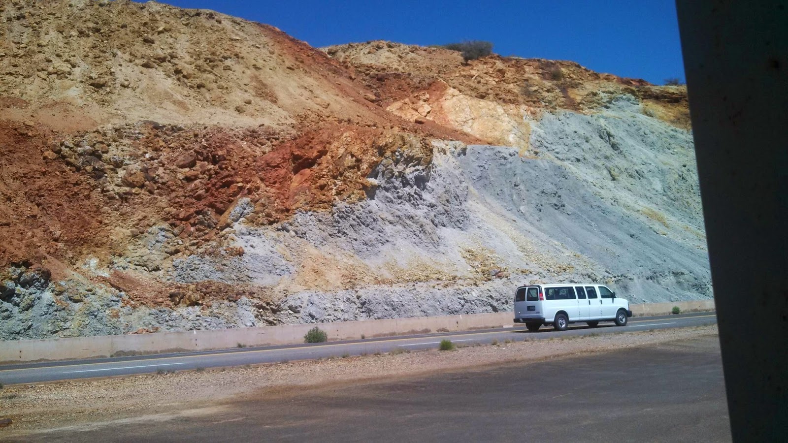
Anyhow, as I left Bisbee, I rode right past the huge copper mine pit that was the main reason for Bisbee existing. It's now also the Cochise County Seat, having grabbed that designation from Tombstone, when Tombstone's silver ran out. The mountains near the mine were beautiful colors, but there were also piles of debris from the mine that were almost as big as the mountains, but more bland, you could even say ugly. AZ 80 continued on a gradual down slope all the way to Douglas, which exists because two copper shelters were built here. AZ 80 treated me right all day, as the shoulder was decent and the rode was mostly smooth. Ten miles from Douglas, the road turned to a four lane, with ten foot shoulders. As I rode into Douglas, a town of 18,000 mostly Hispanics, I began to see some of the bikers who were with the group from Wisconsin, as they were riding around the town, just checking it out, and getting some extra miles. I, too, chose to cruise the town, so I rode a few miles to the Mexican border, and criss crossed the town a couple times, before heading a few miles out of town to the fairgrounds. As I approached my destination, Pam was just coming back in the Jeep from a grocery store run, so she saw some of the town also, before we settled in.

The beautiful scenery

Pretty decent shoulder to ride 

Heading into Mule Pass Tunnel - before the camera wipe out!

POW bell in Douglas

Bike visits with a large soap tree yucca

The rock colors near the copper mine in Bisbee

Copper mine in Bisbee


Miner made of copper in Bisbee