Pam -The motor home was getting a new step motor and it was a rainy day, so we decided to stay in our campsite and make a road trip to Mt St Helens. We each have our memories of the 1980 eruption, but we really didn't know what to expect. We did learn that MSH was not a volcano like the ones in Hawaii, which spew lots of lava out the top. Instead, MSH had a side blast and damaged everything with 300+mph winds, mudslides and pumice. We are going to share our experience with you via our pictures.
 |
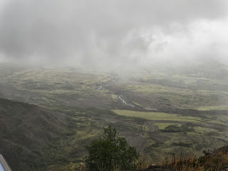
| Yup! It's foggy again!!! Looking down into Toutle Valley - this valley took the mudslides, pumice and ash. The light green area is new growth. The gray area near the top is the old riverbed that was filled with ash, etc. The river is just a small sliver now. |
 |
| Another view of Toutle Valley and river |
 |
| It was freezing here! Look behind Mike at the thick fog |
 |
| A big part of the devastation came from the blast as the side of the volcano blew out. They say the superheated winds were 300+ mph. The blast snapped all the trees for 17 miles out from ground zero! The trees you see in the picture are new growth since 1980. |
 |
| Alot of the trees were removed, but there are still many on the ground. The ground is a gray color left from the volcano mud, pumice and ash. |
 |
| The road, visitor's centers and pull outs were newly built after the volcano changed the landscape. |
 |
| View from the Johnston Ridge Observatory. This is the fancy name for the visitor's center that is at ground zero. This center looks out into the crater of the volcano. We couldn't see the top of Mt St Helen due to the rain and fog. Mike took alot of pictures as the fog shifted, so hopefully you can see something! The observatory is actually 5 miles from the volcano on a cliff, but the view is incredible! Johnston Ridge Observatory is named for the geologist who was monitoring the volcano at that very spot when MSH blew. He was vaporized. |
 |
| The mudslide from the volcano traveled across this valley, up the mountainside, down the next valley and up the next mountain! |
 |
| Fog is lifting, but not enough to show the top of the volcano |
 |
| Looking to the left of MSH |
 |
| All this land was stripped to bedrock, then covered with mud, ash and pumice. After 33 years, Mother Nature is struggling to make the land green again. |
 |
| Weather report for MSH - the weather report for where we are staying in 4-8 inches over the weekend! |
 |
| Since I wasn't cold enough, I had to pose at the Observatory! |
 |
| Every where you look, there is fallen timber still laying around. |
 |
| This is the Toutle River. This picture shows you the layers of mud, pumice, ash and logs. After the eruption, the river was totally blocked and filled with junk. The river eventually started to erode it's way down thru the layers. |
 |
| A day or so after the eruption, so much sediment and ash washed down the Toutle to the Columbia River that they stopped river traffic because the Columbia went from 40' deep to 15' deep!!! Since then, a special dam has been built on the Toutle to filter out the sediment that is still flowing! |
 |
| The trees on the left are Noble Fir trees - they have a very different type of branch that is dark green close to the tree and light green near the ends of the branch. The pictures don't do them justice, but in person, the hillside looks like a 3D picture! It was crazy! Along the road to the volcano, there were areas with different types of trees (Douglas Fir, Noble Fir, etc) planted in 1982 and later to replace the trees destroyed in 1980. |
 |
| On our way home, Mike decided to look for Bigfoot...... |
 |
| And then he found him! |
 |
After a hard day of sightseeing, we stopped at a place called RibEye and Mike had himself a huge prime rib!
|
After listening to weather reports for the weekend, we have decided to stay in place for the weekend. Hopefully it won't rain too hard on Monday when Mike resumes his pedaling!!!


No comments:
Post a Comment