90.4 in 7:06.....I got a half decent start, at 9:00 am (early for me, lately!), because the GPS said it was going to take me 6 hrs. and 51 minutes to do this ride. It's amazing how accurate the GPS has been on the two occasions I've actually used it. I went off course for about 15 minutes to check out 'the center of the world' ( more about that later), so it was about dead on. We crossed the time line when we went into Arizona, so I/we lost an hour, because we are now in the mountain time zone, two hours behind the east. The good news is that it stays light for an hour later now. We were getting bored with the sun setting at 5:30, now it's 6:30 for us.
The first ten miles into El Centro were on a road where I found smooth surface and a bike lane, riding due east, with little wind, and about 65 degrees. The temperature got up to 85, so I packed extra water and Gatorade for the trip through the desert. ( it's supposed to be in the 90's by next week in Yuma..... But hey! It's a dry heat!). I slathered on sunscreen before I left, for the first time since before Labor Day in Seattle. I came to Cali Rt. 86, which would take me south to the small town of Heber, then east to Cali Rt. 111, which took me further south, to Calexico, which is right on the border. Any further south I would be in Mexico, in Calexico's sister city of Mexicali. Mexicali is one of the border cities where the USA returns illegal aliens to their home country, so I was told that there are a lot of disgruntled Mexicans there, and we really have no good reason to go there.
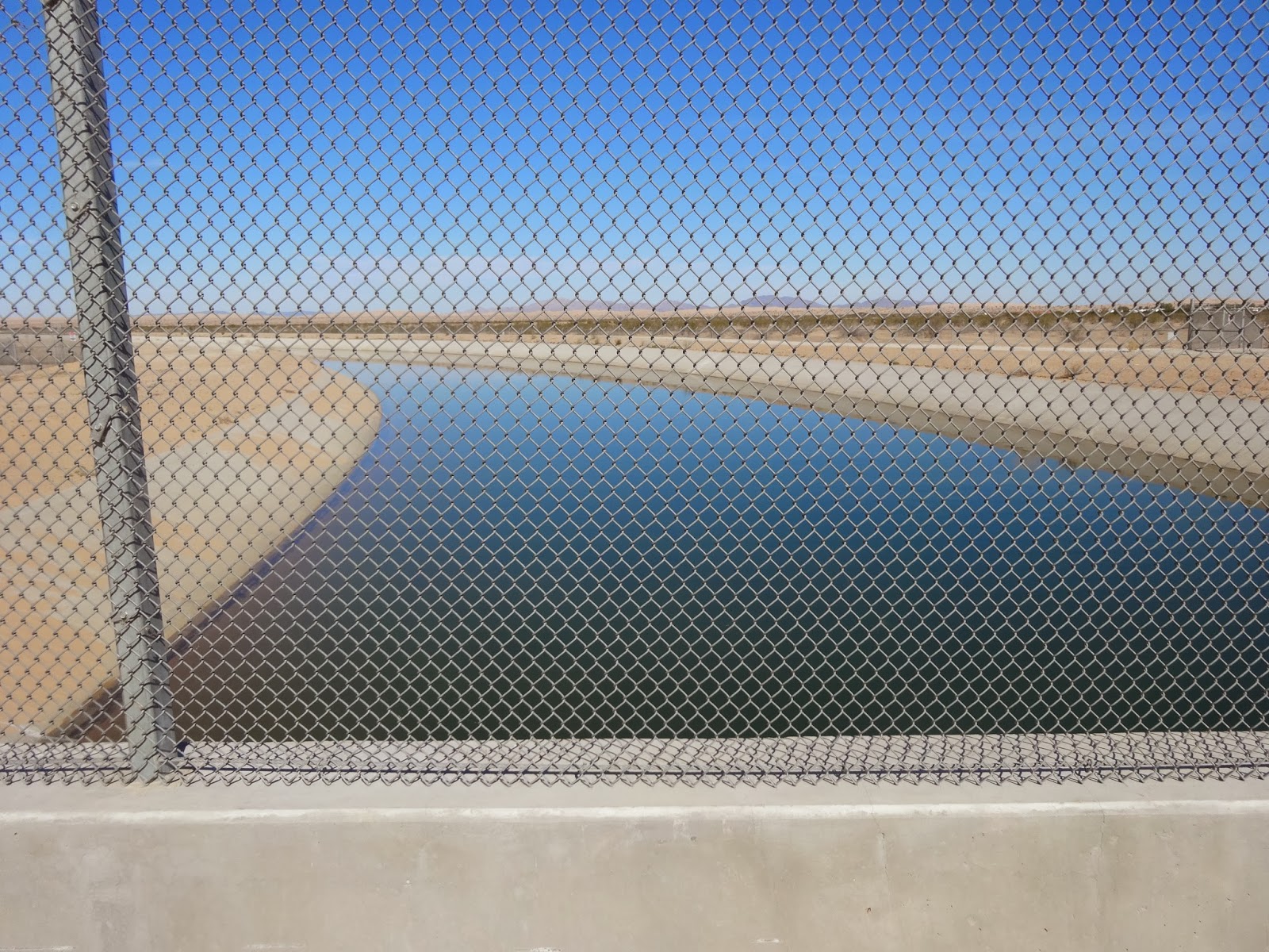
What I did, was pick up Cali Rt. 98, which took me east, very close to the border, through about 10-15 miles of canals and agriculture. The fields were producing Romaine lettuce, red lettuce, alfalfa, and some artichokes, this time of year, and there were the ever present grass fields and bales of hay stacked near the road. The haystacks would provide the ONLY shade, if I would have needed it. This road was also nice, with a big shoulder. I had ridden about 35 miles, and I had not yet felt like I was in the middle of the desert, nor had I hit bad roads, which are more common than not around here. I would rather ride Texas chip seal (my least favorite surface in the country up until this point). The roads here can be the WORST in the country, and I hadn't hit any yet. 98 met up with Interstate 8, the way Pam traveled, and that's where the roads got bad. The frontage roads are not cared for at all when they run right with the interstate, and I spent my time riding the very edge of the road. I actually rode the sand and gravel mixture that was smoother than the gaping cracks and uplifted bumps that dominate the surface of the unkept roads here. At about the same time I met up with the interstate, the agriculture was gone, and scrub trees and sand dominated the scenery. I also was following the USA Canal, which I think is the Colorado River encased in concrete, with a few hydroelectric plants, as small as they were. Eventually, the frontage roads became too much to bear, so I hopped on the interstate, where the shoulders were smooth and clean in most places. At one point the GPS told me to get off onto a frontage road that was all sand. That wasn't going to happen, so I was illegally in I-8 when a California Highway Patrol car screamed at me on the loud speaker as he sped by, to 'get on the frontage road! ' Well, it still wasn't going to happen! The frontage road did turn to asphalt, eventually, and I use the term 'asphalt ' loosely. Eventually I saw the trooper sitting on the shoulder up ahead, just waiting for me, so I stopped, lifted my bike over a barbed wire fence, and climbed over myself. He waved as I went by, and I was being a good boy, but the funny thing is, in less than a mile, I was back on I-8 legally for a few miles. At about the time I got on the interstate, huge dunes of sand appeared, and there was all kinds of people out on their quads and dune buggy type machines, riding the wide open spaces. These dunes were the size of mountains, so there was plenty of area, and steep, steep hills that the ballsy types were riding. There were several boondocking encampments where people had set up for the weekend (boondocking is camping in your RV on federal land, for free, with no power, water source, or sewage, usually as a group, that has community meals and such.) the crazy thing is, out in these desert sand dunes, also ran the canal, which was 50 ft wide with water, and it just seemed out of place.
The sand dunes eventually gave way to civilization, in the form of more plentiful boondock encampments ( mostly Canadian snowbirds I would guess ), and the town of Felicity. This town has zero population, and is the government approved tourist trap that a rich guy built for his girlfriend, Felicity. It consists of a museum, some granite walls with engraving on them, and a chapel, up on top of a large sand dune hill. I rode a few minutes out of my way to check it out, but there was a $3 admission charge, and since I didn't have time to stop, I didn't go in. From there, there were more bad roads, maybe the worst I've ever been on, that led into the town of Winterhaven, which is basically Yuma, but on the California side of the canal. I rode across the canal, and there was no sign welcoming me to Arizona. I would have never have known I crossed the boundary, but I saw a small sign that California had put up on the other side of the road. There is some significance to the border crossing because of the time change.
I got the scenic tour through Yuma by my GPS. I was all over the place as I worked my way from northwest Yuma to southeast Yuma, which is a long way because the town is so spread out. Then, I rode past the Yuma Marine Corps Air Base and the civilian airport, 7-8 more miles, to the Escapee campground where we are going to stay for a while. As I got further out of town, the agriculture ramped up again, with lemon groves, alfalfa, and other crops. I saw a coyote sprint across the road in front of me, and for the first time, out of my half dozen or so coyote sightings on this trip, this guy was at a full sprint. I watched him run 200 yards or so through an alfalfa field, and he never broke stride. Pam told me that she saw a roadrunner in the campground when she pulled in, so between the two of us we saw the whole cartoon, Wile E. Coyote and the Roadrunner!
When I arrived at Escapees, the only site that was available was a dry camping sight, so Pam took that until a site with hook ups opens up, in a couple of days. I had time to grab a quick shower at the bath house, before the ice cream social at the activities room. I got two huge scoops of ice cream, and we stayed when it was over, and watched the Olympics on TV, because you are only allowed to run your generators in dry camping here from 4-6 pm and 8-10 am. I cleaned out the popcorn machine that was there as we watched tv, at a quarter a bag. The diet of champions for dinner tonight! Ice cream and popcorn!


FYI, that picture at the bottom is not a stage coach stop, though it's often misidentified as such. It's known as the Araz adobe ruin, and according to the Arizona Historical Society it was a pump house for the American Girl Mine.
ReplyDelete